
Downloads
Documentation
- PyAPI
- Installation (Ubuntu)
- TclAPI (obsolate)
Demos
Ulyxes
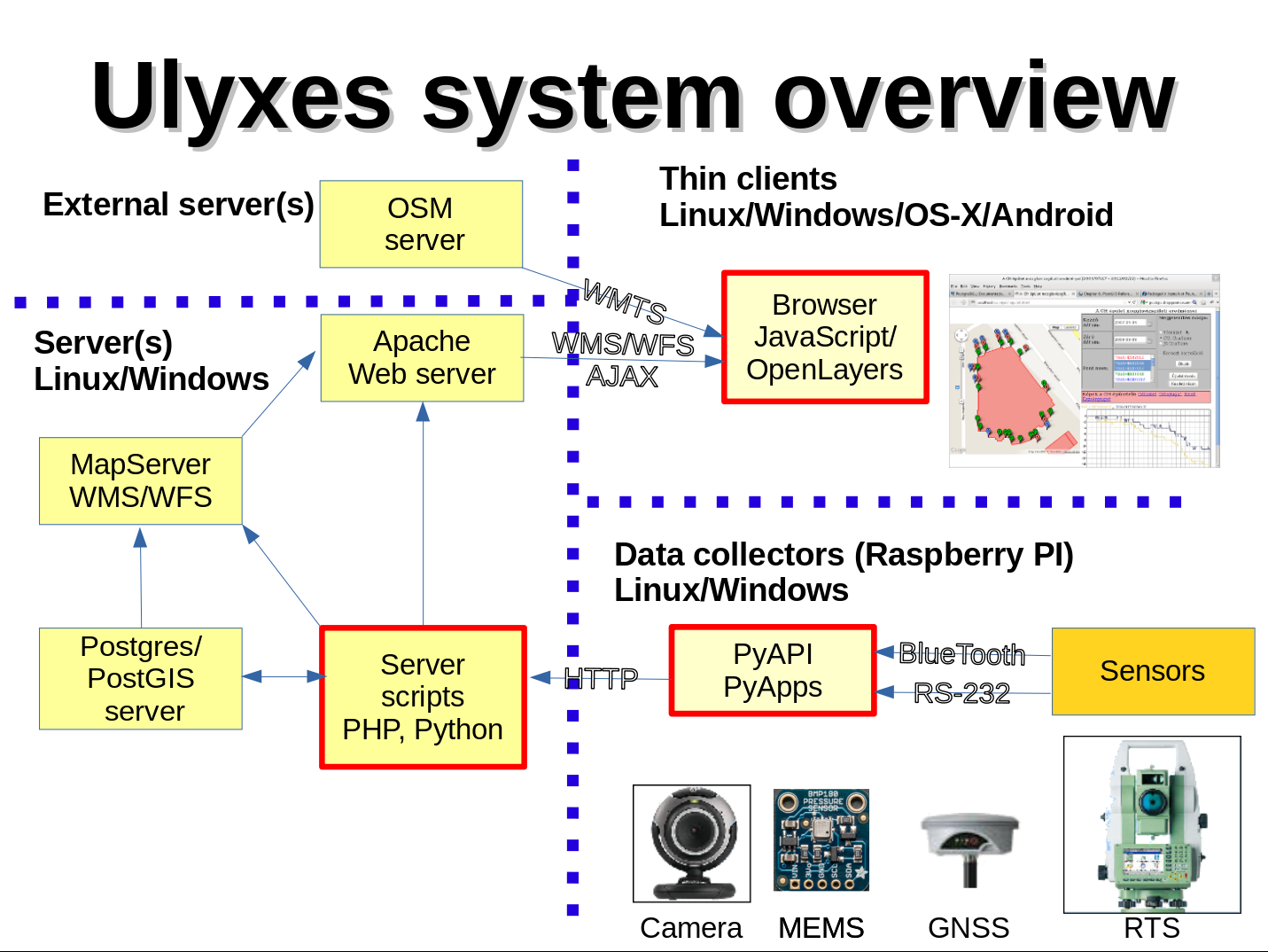
Ulyxes is an open source project to drive robotic total stations (RTS) and other sensors and publish observation results on web based maps (GPL 2)
The aim of the project:
to create a framework to drive robotic total stations from a computer and publish data on the Internet
we want to create a framework not a ready to use application
the project is based on several other open source projects
Statistics
News
New sample application anystation.py added to establish station without approximate coordinates, it is implemented in robotplus.py and horizsection.py 2025.03.30.
STEC Axis 10 support 2024.08.24.
Leica TS 15 support in PyAPI using GeoCom 2022.06.18.
New chart class added (graphplot) using Matplotlib 2021.04.10.
New NMEA messages are handled and redesigned code 2021.01.29.
Improved image processing with template matching and ArUco codes 2020.09.23.
New BlueTooth interface for sensor communication 2019.10.01.
Qt4 library dependency removed from xml file creation and reading, xml.etree is used instead 2019.08.04.
Presentation at OGRS (Open Source Geospatial Research & Education Symposium) 2018, Lugano and a paper.
False prism detection added to robotplus application 2017.10.09.
SQLite writer added to writer family of robotplus application 2016.09.04.
First real life application of robotplus started in Budapest 2017.09.01.
Raspberry Pi camera integrated into the system. 2016.02.09.
New apps were created to serve monitoring tasks robot.py and robotplus.py. 2016.01.30. video
Dowload meteorological data with webmet (virtual) sensor. 2015.12.15.
Collecting and Processing Land Surveyors' Sensor Data presentation at FOSS4G Europe 2015, Como
First 9 DOF sensor (FLORA Adafruit LSM9DS0) integrated through the i2c interface of a Raspberry Pi. It can be used for indoor navigation. 2015.05.22.
WiFi signal collector integrated into the system, useful for WiFi fingerprinting. 2015.04.19.
Adafruit BMP180 air pressure sensor integrated into the system through the i2c of a Raspberry Pi, used to measure height differences 2015.04.04.
USB WebCams integrated into the system to detect movements, used during test load of bridges 2015.01.10.
Presentation at FOSS4G-CEE & Geoinformatics 2012 Prague
© Zoltán Siki, siki.zoltan (kukac) epito.bme.hu
Developers
Zoltán Siki
Bence Takács
Bence Hrutka
Szonja Zemkó
Dániel Moka
Tamás Király
Viktória Zubály
József Jankó
Dávid Bánhidi
Bence Turák
Máté Kecskeméti
Tested sensors
- Leica TS 15i
- Leica TCA1800
- Leica TCRP1201+
- Leica TCRA1103
- Leica DNA03
- STEC Axis 10
- Trimble 5503DR
- Garmin GPS18
- Leica GPS 500
- U-blox F9P
- TopCon HiperPro II
- USB WebCam
- Adafruit BMP180
- Adafruit LSM9DS0
- RasPi camera
- RasPi SenseHat